One of the advantages of living where I do, on the fringes of the Lake District National Park, is the ability to go backpacking from the front door. Last year I did two trips, one camping on Caudale Moor, day one here, and day two here, and the other camping on Thornthwaite Crag which can be found here.
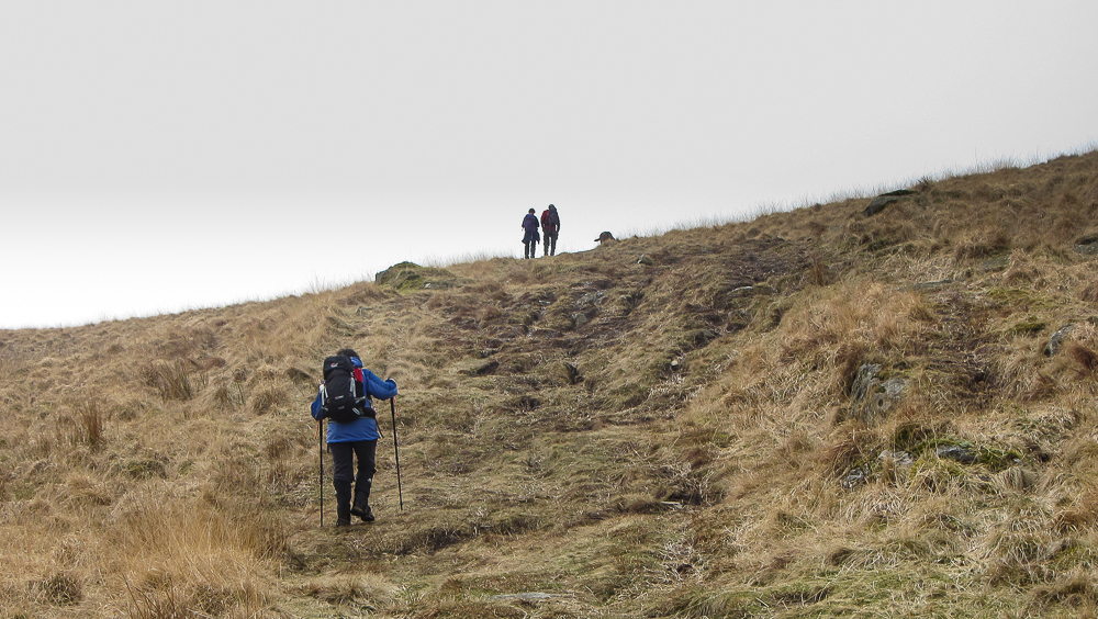
Another advantage is that if your other half, Sian my wife in my case, wants to come for a walk, they can accompany you part way and then return home to a comfortable bed. So that’s how on Tuesday 17th of March Sian and I set off from home.
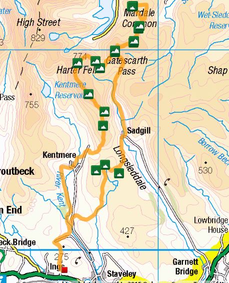
A bit of road walking took us down Browfoot Lane, a favorite way for mountain bikes to get to the bridleways of Kentmere Park, then a pleasant off road section brought us to Ulthwaite Bridge just off the Staveley to Kentmere road. A few hundred meters along this road took us to a bridle path to climb up towards the Green Quarter Fells.

The three Green Quarter fells are a tight group marking the high point between the Kentmere and Longsleddale valleys. They are a mixture of Wainwright’s Outlying Fells and Birkett’s . Having “bagged” these three it was time for Sian to head home and me to drop down to Sadgill in Longsleddale.


Many of you will know Sadgill as it’s where the road in Longsleddale ends and there are a few unofficial car parking spaces making an ideal start for walking the Wainwrights of Grey Crag and Tarn Crag. I had planned to have a break by the bridge, a spot of lunch and to top up my water supplies from the river. As I got there a lady vacated the bench. It was 12.15 and I was to see no one else, save a distant glimpse of a couple of fell runners, until 9.45am the following day. Who says you can’t get peace and solitude in the Lake District.


After a bite to eat I set off up Longsleddale. The road becomes a track going north from Sadgill. I continued for about another 3k, steadily gaining height until I reached the delightfully named Brownhowe Bottom at which point a bridle path heads off in an easterly direction to Mosedale and eventually Wet Sleddale. I took this path and decided it was time for lunch mark 2.


So far all the climbing had been fairly gentle. This was about to change as I started the steep grassy climb to gain Selside Brow and then continued on and up towards Branstree. The plan was to camp somewhere between Branstree and Selside Pike, possibly by the old observation pillar on Pillar. The problem was that there had clearly been a lot of snow up here, some of which remained, but what had melted had turned the area to bog.
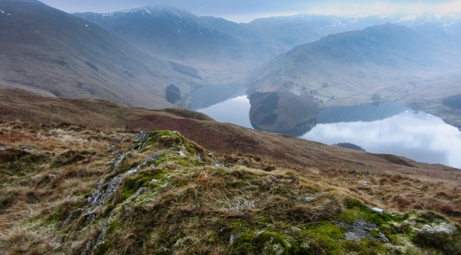
I took quite a few detours to possible camp spots on the walk from Branstree to Selside Pike via Pillar but found nowhere I was happy with. On Selside Pike I considered my options. There was a relatively dry flat pitch by the summit but I had not yet picked up any water. I could have melted some snow but as it was only 3.30 I decided to drop down towards the Old Corpse Road which has a beck running beside it. I took my pack in case I could find a better pitch. Once I was below the snow line the ground become very dry. I made good progress down to the beck. I then decided to look for a pitch on the other side of the Corpse Road on Brown Howe. This turned out to be an excellent idea as I soon found a good spot with views over Hawswater down to The Rigg. It was now 4pm, time to set up camp with about two and a half hours daylight left.


Now I have to confess I’m not a winter camper. Not so much because of the cold but the long dark nights. Spending long hours in the tent is not my idea of fun. Having said that I’ve now got a kindle paperwhite and combined with music from my phone time soon passes. This was to be the night of the aurora. Despite the fact that most of the sky became clear the northern horizon remained hazy, so no aurora for me.
I got up for a call of nature about 4pm, the sky was clear, except to the north, and the temperature had dropped well below freezing. My trail shoes were frozen!
I got up about 6.30 and the tent was frozen solid with lumps of condensation ice. The clear skies had now been replaced with haze and the tops of Branstree and Harter Fell were in cloud.


By 8.00am I was on my way again.The plan was to retrace my route from yesterday as far as Branstree then to climb Harter Fell and take the ridge down to Kentmere and the a low level route back home.


From Branstree I dropped down to Gatesgarth Pass, picked up some water, and had a break. Just as I was packing up a noise startled me as another walker came up the path. The first person I’d seen in over 21 hours. I climbed up Harter Fell, with a short detour to take in Adams Seat. There were some quite significant snow banks still here. The sun was threatening to burn off the clouds giving a strange light. It finally succeeded between Harter Fell and Kentmere Pike.


Now if you are doing the Kentmere Round most people head straight from Kentmere Pike to Shipman Knotts missing out the small detour to Goat Scar a “Birkett”. Its worth taking the detour then just by Goat Scar is a stile, cross this and head to an obvious cairn less than 50m away. This is a fabulous viewpoint for Longsleddale.


From here it was over Shipman Knotts, through the delightful village of Kentmere, back along the Kentmere Valley to Browfoot and home.


Day 1 was 14.4 miles with 3600ft of ascent and 2500ft of descent.
Day 2 was 13.5 miles with 2500ft of ascent and 3600ft of decent.
Total 27.9 miles with 6100ft of climbing. A good bit of training for the TGO challenge which I start on May 8th. All the kit I took worked fine and I was particularly pleased with my trail shoes this being my first backpack wearing them.

I’m still waiting my chance to get out for an overnight before the TGO. I’d planned to get out at least twice…but the weeks are slipping by. All these photo’s of tents pitched high up in the hills are making me exceedingly jealous. Looks like a grand couple of days out.
What trail shoes did you take by the way ?
LikeLike
I think I got the last pair of Inov-8 TERROC
LikeLike
Going up to the Lakes tomorrow, to make a start on the Cumbria Way on Saturday. Weather forecast looks decidedly worse than the dryness you seem to have just had!
LikeLike
One of the advantages of being a) retired and B) living in the Lakes is that you can get out when the weather is good. Although because of the weather we have up here you also have to get wet from time to time :-(. Do you follow @adrianstrand think hes doing the Cumbrian Way at about the same time.I hope the weather is considerably better than forecast. Look forward to the posts
LikeLike
Like you, I am actually retired, but the friend I’m doing it with isn’t, so unfortunately we’re still tied to school holidays for this one.
Don’t think I know Adrian Strand – I’ll have a look 🙂
LikeLiked by 1 person
Fine training walk that. Good luck with other training walks before the Challenge Paul.
LikeLike
Thanks Martin. How was the Cairngorms trip?
LikeLike
Nice write up of an area i know well. Sadgill is a lovely spot to start a walk from. You’ve made the whole trip sound easy and were well prepared.
LikeLike
Thanks Jim
LikeLike
Nice trip Paul, I hope to get out over the Easter break. I’m like you winter camping has lost it’s appeal…to many long hours in the dark for me. that shouldn’t be a problem on the TGOC in May 🙂
LikeLike
Thanks Alistair only 6 weeks to go to TGOC. Where are you starting?
LikeLike
Yes..it’s coming round quickly now. I’ve just been cutting my maps down. One of my parcels is travelling up over Easter with a friend! I’m starting from Mallaig.
LikeLiked by 1 person
Good trip. Lovely area. I like the idea of trail shoes but i like dry feet. Not sure i could stand damp socks all day. But i will never say never.
LikeLike
I was equally doubtful about the trail shoes but the weight saving on your feet for backpacking is worth it. Will still wear boots on day walks unless it’s dry underfoot
LikeLike
Nice write up and Pictures Paul 🙂
LikeLike
Nice write up and pictures Paul 🙂
LikeLike
Thanks Lee. I have to approve the first comment by each person posting on my site. Now that I’ve done it, any future comments from you should go straight on.
LikeLike